"BIRDING SITES OF NOVA SCOTIA"
A Comprehensive, Year-Round Guide for Birders
and Other Nature Lovers
|
Site Introduction
"Birding Sites of Nova Scotia" uses this web site to offer links to useful, relevant web resources, thereby saving valuable space in the book, and making it possible to maintain the links' accuracy and currency. As well, this saves you, the reader, from having to re-type the URLs into your computer. For information on how to use the locator maps, click here. The Information Links are divided by county, with a separate page for province-wide resources. Within each county the links are divided by category, including: Tourism
Information & Orientation
Locator Maps for Birding Sites & Routes County Birding Site Updates Weather & Tides Trails Parks & Protected Areas Cultural Heritage Attractions Lighthouses Author's Recommendations The web
site will also be used to provide
updates, corrections, and additions. Note: Maps in PDF format have been designed for the inside back and front covers of the Guide: Counties of Nova Scotia Overview of Nova Scotia Just Print, Cut, and Paste (Note: print with the following dimensions: 20 cm x 13 cm = 7.75" x 5.0 ") Please
contact me if you
have comments, corrections, clarifications,
or would like to promote a new site or route. I also welcome species lists and landscape photos for any of the sites and routes described in the guide. To Order "Birding Sites of Nova Scotia" |
| INFORMATION WEB LINKS |
| PROVINCE WIDE |
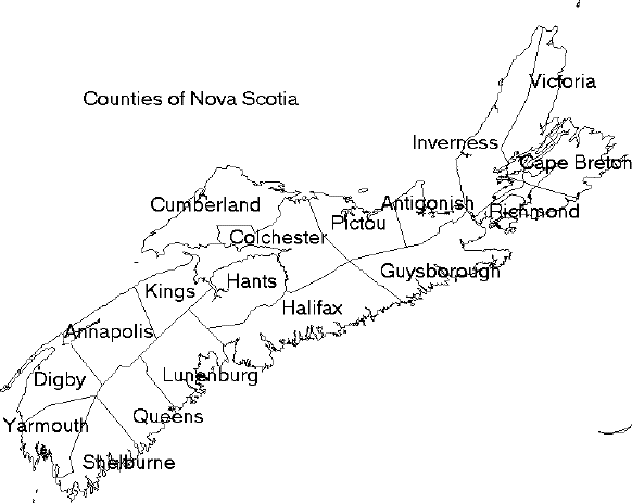
| BY COUNTY OR MUNICIPALITY (Click here for the counties' map) |
| ANNAPOLIS
COUNTY |
| ANTIGONISH COUNTY |
| CAPE
BRETON REGIONAL MUNICIPALITY |
| COLCHESTER COUNTY |
| CUMBERLAND COUNTY |
| DIGBY COUNTY |
| GUYSBOROUGH COUNTY |
| HALIFAX REGIONAL
MUNICIPALITY |
| HANTS COUNTY |
| INVERNESS
COUNTY |
| KINGS COUNTY |
| LUNENBURG COUNTY |
| PICTOU COUNTY |
| QUEENS COUNTY |
| RICHMOND COUNTY |
| SHELBURNE
COUNTY |
| VICTORIA COUNTY |
| YARMOUTH COUNTY |
| BOOK UPDATES |
| Nova Scotia Maps |
| Maps
in PDF format have been designed for the inside back and front covers
of the Guide: Counties of Nova Scotia Overview of Nova Scotia Just Print, Cut, and Paste (Note: print with the following dimensions: 20 cm x 13 cm = 7.75" x 5.0 ") |
| Order
a Free Nova Scotia Highway Map
either Online or by Phone: 1-800-565-0000 (Canada & United States) |
| On-line Road Map of Nova Scotia |
| On-line Map of Nova Scotia's Counties |
|
Locator Map Notes
I use Mapquest mapping to help orientate readers to the birding sites and routes described in my book. The site is indicated by the red star at the centre of the map. The scale of Mapquest maps may be manipulated by zooming in and out using the sliding bar immediately to the right of the map, and any map may be shifted towards the eight points of the compass simply by clicking the borders or the corners of the map edge. For most of the sites it is usually helpful to zoom in to better orientate yourself. The physical location of roads and natural features is usually fairly accurate, but the locations for small village and hamlets are frequently slightly mis-placed. And, occasionally, very strange things happen, such as the frequent appearance of “Great Slave Lake” over the waters of the Atlantic Ocean. Ignore these quirks, treasure them, or embrace the fallibility of computers.. Note: Mapquest road names, especially in rural areas, are occasionally inaccurate, and rural roads, despite their theoretical designation, are very often are not signed at all “on the ground”. “The maps are informational only. No representation is made or warranty given as to their content. User assumes all risk of use. MapQuest and its suppliers assume no responsibility for any loss or delay resulting from such use.” To supplement the Mapquest maps, I also often supply aerial maps through Google. The amount of available detail varies according to the most detailed satellite imagery available; for some portions of the province the detail is considerable. I offer maps where I think users will learn more regarding the geography of a site or route. |
 |
|---|
 |
|
||||||||||||||||||||||||